GEN 3.2 Aeronautical charts
1 Responsible services
2 Maintenance of charts
Aeronautical Chart — ICAO 1:500 000 in digital format contains the latest aeronautical information.
3 Purchase arrangements
Post: Aeronautical Information Service Tel: (+995 32) 274 42 37 Tel: (+995 32) 274 42 23 Fax: (+995 32) 274 42 23 AFS: UGTBYOYX |
4 Aeronautical chart series available
- Aerodrome/Heliport Chart — ICAO;
- Aerodrome Ground Movement Chart — ICAO;
- Aircraft Parking/Docking Chart — ICAO;
- Aerodrome Obstacle Chart — ICAO – Type A;
- En-route Chart — ICAO;
- Area Chart — ICAO (arrival, departure and transit routes);
- Standard Departure Chart – Instrument (SID) — ICAO;
- Standard Arrival Chart – Instrument (STAR) — ICAO;
- ATC Surveillance Minimum Altitude Chart — ICAO;
- Instrument Approach Chart — ICAO (for each runway and procedure type);
- Visual Approach Chart — ICAO;
- Aeronautical Chart — ICAO 1:500 000 (also available in digital format - Geo TIFF, Geospatial PDF);
- Index Charts:
- AIRMET/GAMET areas;
- Radar coverage area;
- Prohibited, Restricted, Military exercise and Training areas;
- Bird Migration Routes;
- Bird Concentrations and Movement;
- Free Route Airspace;
- En-route ATC Surveillance Minimum Altitude Chart.
The charts currently available are listed under para 5 of this subsection.
4.2 General description of each series
- Aerodrome Chart — ICAO. This chart contains detailed aerodrome data to provide flight crews with information that will facilitate the ground movement of aircraft:
- from the aircraft stand to the runway; and
- from the runway to the aircraft stand.
It also provides essential operational information at the aerodrome. - Aerodrome Ground Movement Chart — ICAO. This chart is produced for those aerodromes where, due to congestion of information, details necessary for the ground movement of aircraft along the taxiways to and from the aircraft stands and for the parking/docking of aircraft cannot be shown with sufficient clarity on the Aerodrome Chart — ICAO.
The chart is produced in combination with the Aircraft Parking/Docking Chart — ICAO for Tbilisi aerodrome. - Aircraft Parking/Docking Chart — ICAO. This chart is produced for those aerodromes where, due to the complexity of the terminal facilities, the information to facilitate the ground movement of aircraft between the taxiways and the aircraft stands and the parking/docking of aircraft cannot be shown with sufficient clarity on the Aerodrome Chart — ICAO or on the Aerodrome Ground Movement Chart — ICAO.
The chart is produced in combination with the Aerodrome Ground Movement Chart — ICAO for Tbilisi aerodrome. - Aerodrome Obstacle Chart — ICAO — Type A (operating limitation). This Chart contains detailed information on obstacles in the take–off flight path areas of aerodromes. It is shown in plan and profile view.
- En-route Chart — ICAO. This chart is produced for the entire TBILISI FIR. The aeronautical data include all aerodromes, prohibited, restricted and danger areas and the ATS system in detail. The chart provides the flight crew with information that will facilitate navigation along ATS routes in compliance with Air traffic services procedures.
- Area Chart — ICAO. This chart is produced when the ATS routes or position reporting requirements are complex and cannot be shown on an En-route Chart — ICAO.
It shows, in more detail, those aerodromes that affect terminal routings, prohibited, restricted and danger areas and the air traffic services system. This chart provides the flight crew with information that will facilitate the following phases of instrument flight:
- the transition between the en-route phase and the approach to an aerodrome;
- the transition between the take-off/missed approach and the en-route phase of flight; and
- flights through areas of complex ATS routes or airspace structure.
- Standard Departure Chart — Instrument (SID) — ICAO. This chart is produced whenever a standard departure route — instrument has been established and cannot be shown with sufficient clarity on the Area Chart — ICAO.
The aeronautical data shown include the aerodrome of departure, aerodrome(s) which affect the designated standard departure route — instrument, prohibited, restricted and danger areas and the air traffic services system. This chart provides the flight crew with information that will enable them to comply with the designated standard departure route — instrument from the take-off phase to the en-route phase.
- Standard Arrival Chart — Instrument (STAR) — ICAO. This chart is produced whenever a standard arrival route — instrument has been established and cannot be shown with sufficient clarity on the Area Chart — ICAO.
The aeronautical data shown include the aerodrome of landing, aerodrome(s) which affect the designated standard arrival route — instrument, prohibited, restricted and danger areas and the air traffic services system. This chart provides the flight crew with information that will enable them to comply with the designated standard arrival route — instrument from the en-route phase to the approach phase.
- ATC Surveillance Minimum Altitude Chart— ICAO. This supplementary chart provides information that will enable flight crews to monitor and cross-check altitudes assigned while under radar control.
- Instrument Approach Chart — ICAO. This chart is produced for all aerodromes used by civil aviation where instrument approach procedures have been established. A separate Instrument Approach Chart — ICAO has been provided for each approach procedure.
The aeronautical data shown include information on aerodromes, prohibited, restricted and danger areas, radio communication facilities and navigation aids, minimum sector altitude, procedure track portrayed in plan and profile view, etc.
This chart provides the flight crew with information that will enable them to perform an approved instrument approach procedure to the runway of intended landing including the missed approach procedure and where applicable, associated holding patterns. - Visual Approach Chart — ICAO. This chart is produced for aerodromes used by civil aviation where:
- only limited navigation facilities are available; or
- radio communication facilities are not available; or
- no adequate aeronautical charts of the aerodrome and its surroundings at 1:500 000 or greater scale are available; or
- visual approach procedures have been established.
The aeronautical data shown include information on aerodromes, obstacles, designated airspace, visual approach information, radio navigation aids and communication facilities, as appropriate.
- Aeronautical Chart — ICAO 1:500 000. This series is constructed on Transverse Mercator projection. The aeronautical data shown are consistent with the use of short and medium range operations and depict all relevant features. The chart includes a selection of aerodromes, significant obstacles, elements of ATS system, special activities areas, radio navigation aids and etc. The chart provides the information to satisfy visual air navigation and also used as a pre-flight planning chart.
Note. – This chart does not form part of the AIP of Georgia.
- Index Charts. Some parts of the AIP of Georgia are supplemented by index charts:
- AIRMET/GAMET areas – Index Chart — 1:2 500 000. This chart shows AIRMET sectors in the TBILISI FIR;
- Radar coverage area – Index Chart — 1:2 500 000. This chart shows the graphic portrayal of radar coverage area at the different flight levels in the TBILISI FIR;
- Prohibited, Restricted, Military exercise and Training areas – Index Chart — 1:2 200 000. This chart is produced for the entire TBILISI FIR. The aeronautical data include in compendious form all Prohibited, Restricted, Military exercise and Training areas as listed under subsections ENR 5.1, ENR 5.2;
- Bird Migration Routes – Index Chart — 1:2 500 000. This chart shows the major directions of the bird migration, main migration corridors and bird concentration in the TBILISI FIR and on aerodromes;
- Bird Concentrations and Movement – Index Chart. This chart shows the bird concentrations in the vicinity of an aerodrome;
- Free Route Airspace – Index Chart — 1:1 500 000. This chart shows South Caucasus cross border Free Route Airspace within TBILISI FIR;
- En-route ATC Surveillance Minimum Altitude Chart — Index Chart — 1:1 500 000. This supplementary chart provides information that will enable flight crews to monitor and cross-check altitudes assigned while under radar control within TBILISI CTA.
5 List of aeronautical charts available
| Title of series | Scale | Name and/or number | Price ($) | |
|---|---|---|---|---|
| Aerodrome Chart – ICAO | 1:15 000 | TBILISI/Tbilisi | AD 2.UGTB-ADC | |
| KUTAISI/Kopitnari | AD 2.UGKO-ADC | |||
| BATUMI | AD 2.UGSB-ADC | |||
| 1:6 000 | MESTIA | AD 2.UGMS-ADC | ||
| NATAKHTARI | AD 2.UGSA-ADC | |||
| AMBROLAURI | AD 2.UGAM-ADC | |||
| 1:9 000 | TELAVI | AD 2.UGGT-ADC | ||
| Aircraft Parking and Ground Movement Chart – ICAO | 1:6 000 | TBILISI/Tbilisi | AD 2.UGTB-APGMC | |
| Aerodrome Obstacle Chart – ICAO –Type A | 1:35 000 | TBILISI/Tbilisi | AD 2.UGTB-AOC-A | |
| 1:20 000 | BATUMI | AD 2.UGSB-AOC-A | ||
| En-route Chart – ICAO | 1:1 500 000 | Lower ATS Routes | ENR 6-3 | |
| Area navigation (RNAV) Routes | ENR 6-5 | |||
| Prohibited, Restricted, Military exercise and training areas Chart – Index chart | 1:2 200 000 | Georgia | ENR 6-7 | |
| Bird Migration Chart – Index chart | 1:2 500 000 | Bird Migration Routes (Spring) | ENR 6-9 | |
| Bird Migration Routes (Autumn) | ENR 6-11 | |||
| Area Chart – ICAO | 1:700 000 | TBILISI/Tbilisi TMA | AD 2.UGTB-ARC | |
| KUTAISI/Kopitnari TMA | AD 2.UGKO-ARC | |||
| Standard Departure Chart – Instrument (SID) – ICAO | 1:500 000 | TBILISI/Tbilisi | ||
| UGTB RNAV RWY13R | AD 2.UGTB-SID-RNAV-13R-1 | |||
| UGTB RNAV RWY31L | AD 2.UGTB-SID-RNAV-31L-1 | |||
| UGTB RWY13R/31L | AD 2.UGTB-SID-13R/31L-1 | |||
| KUTAISI/Kopitnari | ||||
| UGKO RWY07 | AD 2.UGKO-SID-07 | |||
| UGKO RWY25 | AD 2.UGKO-SID-25 | |||
| BATUMI | ||||
| UGSB RWY31 (NEDEK 1A, SOSED 1A, SARPI 1A) | AD 2.UGSB-SID-31-SOSED | |||
| UGSB RWY31 (SARPI 3A, SARPI 4A) | AD 2.UGSB-SID-31 | |||
| Standard Arrival Chart – Instrument (STAR) – ICAO | 1:550 000 | TBILISI/Tbilisi | ||
| UGTB RNAV RWY13R | AD 2.UGTB-STAR-RNAV-13R | |||
| UGTB RNAV RWY31L | AD 2.UGTB-STAR-RNAV-31L | |||
| 1:500 000 | KUTAISI/Kopitnari | |||
| UGKO RWY07-25 | AD 2.UGKO-STAR-07-25 | |||
| BATUMI | ||||
| UGSB RWY13 | AD 2.UGSB-STAR-13 | |||
| Instrument Approach Chart – ICAO | 1:500 000 | TBILISI/Tbilisi | ||
| UGTB ILSy RWY13R | AD 2.UGTB-IAC-13R-ILSy | |||
| UGTB ILSy RWY31L | AD 2.UGTB-IAC-31L-ILSy | |||
| UGTB ILSz RWY13R | AD 2.UGTB-IAC-13R-ILSz-1 | |||
| UGTB ILSz RWY31L | AD 2.UGTB-IAC-31L-ILSz-1 | |||
| UGTB LOCy RWY13R | AD 2.UGTB-IAC-13R-LOCy | |||
| UGTB LOCy RWY31L | AD 2.UGTB-IAC-31L-LOCy | |||
| UGTB LOCz RWY13R | AD 2.UGTB-IAC-13R-LOCz-1 | |||
| UGTB LOCz RWY31L | AD 2.UGTB-IAC-31L-LOCz-1 | |||
| UGTB VOR RWY13R | AD 2.UGTB-IAC-13R-VOR | |||
| UGTB VOR RWY31L | AD 2.UGTB-IAC-31L-VOR | |||
| KUTAISI/Kopitnari | ||||
| UGKO ILS/DME or LOC y RWY07 | AD 2.UGKO-IAC-07-ILS y | |||
| UGKO ILS/DME or LOC z RWY07 | AD 2.UGKO-IAC-07-ILS z | |||
| UGKO ILS/DME or LOC y RWY25 | AD 2.UGKO-IAC-25-ILS y | |||
| UGKO ILS/DME or LOC z RWY25 | AD 2.UGKO-IAC-25-ILS z | |||
| UGKO VOR/DME y RWY07 | AD 2.UGKO-IAC-07-VORy | |||
| UGKO VOR/DME z RWY07 | AD 2.UGKO-IAC-07-VORz | |||
| UGKO VOR/DME y RWY25 | AD 2.UGKO-IAC-25-VORy | |||
| UGKO VOR/DME z RWY25 | AD 2.UGKO-IAC-25-VORz | |||
| BATUMI | ||||
| 1:250 000 | UGSB ILS/DME or LOC RWY13 | AD 2.UGSB-IAC-13-ILS | ||
| UGSB NDB/DME RWY13 (CAT A,B) | AD2.UGSB-IAC-13-NDB-AB | |||
| UGSB NDB/DME RWY13 (CAT C,D) | AD2.UGSB-IAC-13-NDB-CD | |||
| ATC Surveillance Minimum Altitude Chart – ICAO | 1:700 000 | TBILISI/Tbilisi | AD 2.UGTB-ATCSMAC-1 | |
| 1:700 000 | KUTAISI/Kopitnari | AD 2.UGKO-ATCSMAC | ||
| 1:500 000 | BATUMI | AD 2.UGSB-ATCSMAC | ||
| Visual Approach Chart – ICAO | 1:300 000 | TBILISI/Tbilisi | AD 2.UGTB-VAC | |
| 1:500 000 | KUTAISI/Kopitnari | AD 2.UGKO-VAC | ||
| BATUMI | AD 2.UGSB-VAC | |||
| 1:200 000 | AMBROLAURI | AD 2.UGAM-VAC | ||
| MESTIA | AD 2.UGMS-VAC | |||
| NATAKHTARI | AD 2.UGSA-VAC | |||
| TELAVI | AD 2.UGGT-VAC | |||
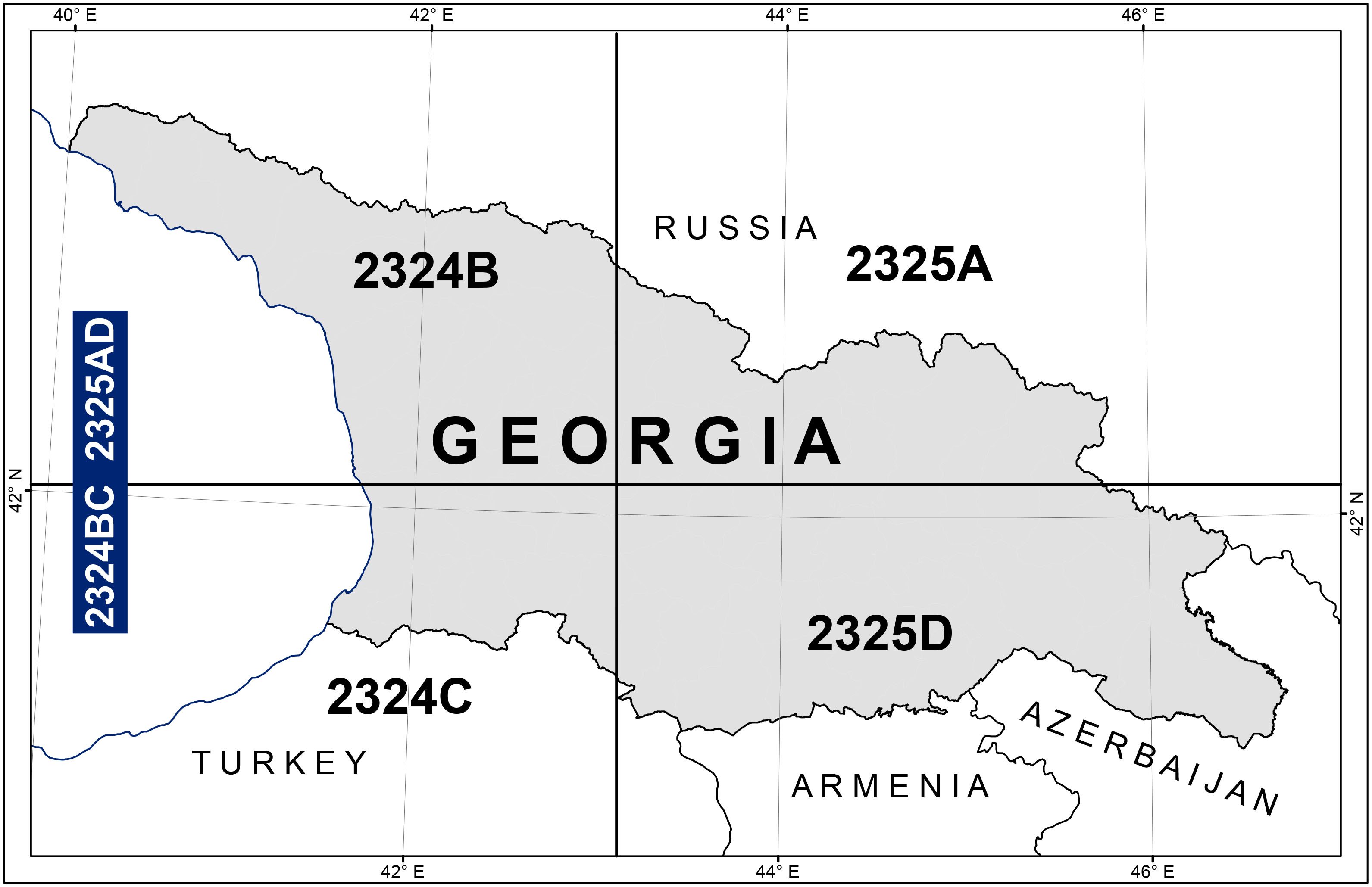
| Aeronautical Chart – ICAO* | 1:500 000 | Georgia 2020 Edition | 2324BC2325AD | |
| AIRMET/GAMET areas – Index Chart | 1:2 500 000 | AIRMET/GAMET areas | GEN 3.5-7 | |
| Radar coverage area – Index Chart | 1:2 500 000 | Graphic portrayal of SSR coverage area | ENR 1.6-3 | |
| ENR 1.6-5 | ||||
| ENR 1.6-7 | ||||
| ENR 1.6-9 | ||||
| Bird Concentrations and Movement – Index Chart | 1: 60 000 | TBILISI/Tbilisi | AD 2.UGTB-BIRD | |
| 1: 15 000 | KUTAISI/Kopitnari | AD 2.UGKO-BIRD | ||
| 1: 20 000 | BATUMI | AD 2.UGSB-BIRD | ||
| 1: 10 000 | AMBROLAURI | AD 2.UGAM-BIRD | ||
| Free Route Airspace – Index Chart | 1:1 500 000 | Free Route Airspace South Caucasus (FRASC) | ENR 6-13 | |
| En-route ATC Surveillance Minimum Altitude Chart − Index Chart | 1:1 500 000 | En-route ATC Surveillance Minimum Altitude Chart | ENR 6-15 | |
Those chart series marked by an asterisk (*) do not form part of the AIP of Georgia.
6 Index to the Aeronautical Chart — ICAO 1: 500 000
7 Topographical charts
Post: Geodesy and Geo Information Department of Tel: (+995 32) 225 15 28 Fax: (+995 32) 225 15 28 AFS: NIL Email: info@napr.gov.ge URL: https://napr.gov.ge/ |
8 Corrections to charts not contained in the AIP
| Charts | Location | Corrections |
|---|---|---|
| Aeronautical Chart – ICAO 1: 500 000 Georgia 2324BC2325AD | 2020 Edition WEF 03 DEC 2020 The publication of this issue invalidates the previous issue | |
| Tbilisi TMA | New TMA | |
| Tbilisi CTR | New CTR | |
| Tbilisi UGTB | Tbilisi AD Elevation 1578 FT | |
| Tbilisi TMA | New significant point BAZIK added 412741.5N 0450335.1E | |
| Tbilisi TMA | New significant point DANQI added 415611.3N 0443640.5E | |
| Tbilisi TMA | New significant point GEMNA added 413134.7N 0451503.4E | |
| Tbilisi TMA | New significant point LATVA added 414900N 0443445E | |
| Tbilisi TMA | New significant point NAMME added 415308.8N 0444033.6E | |
| Tbilisi TMA | New significant point NATIP added 413107.6N 0450825.5E | |
| Tbilisi TMA | New significant point PALLE added 412835N 0441925E | |
| Tbilisi TMA | New significant point UDVIN added 415717.3N 0444622.9E | |
| Tbilisi TMA | New significant point ZAGOT added 414706N 0440811E |