ENR 1.14 Air traffic incidents
1 Definition of air traffic incidents
- aircraft proximity (AIRPROX);
- serious difficulty resulting in a hazard to aircraft caused, for example, by:
- faulty procedures,
- non-compliance with procedures,
- failure of ground facilities, or
- any other event.
Risk of collision. The risk classification of aircraft proximity in which serious risk of collision has existed.
Safety not assured. The risk classification of aircraft proximity in which the safety of the aircraft may have been compromised.
No risk of collision. The risk classification of aircraft proximity in which no risk of collision has existed.
Risk not determined. The risk classification of aircraft proximity in which insufficient information was available to determine the risk involved, or inconclusive or conflicting evidence precluded such determination.
AIRPROX. The code word used in an air traffic incident report to designate aircraft proximity.
| Type | Designation |
| Air traffic incident | Incident |
| as a) above | AIRPROX (aircraft proximity) |
| as b) 1) and 2) above | Procedure |
| as b) 3) above | Facility |
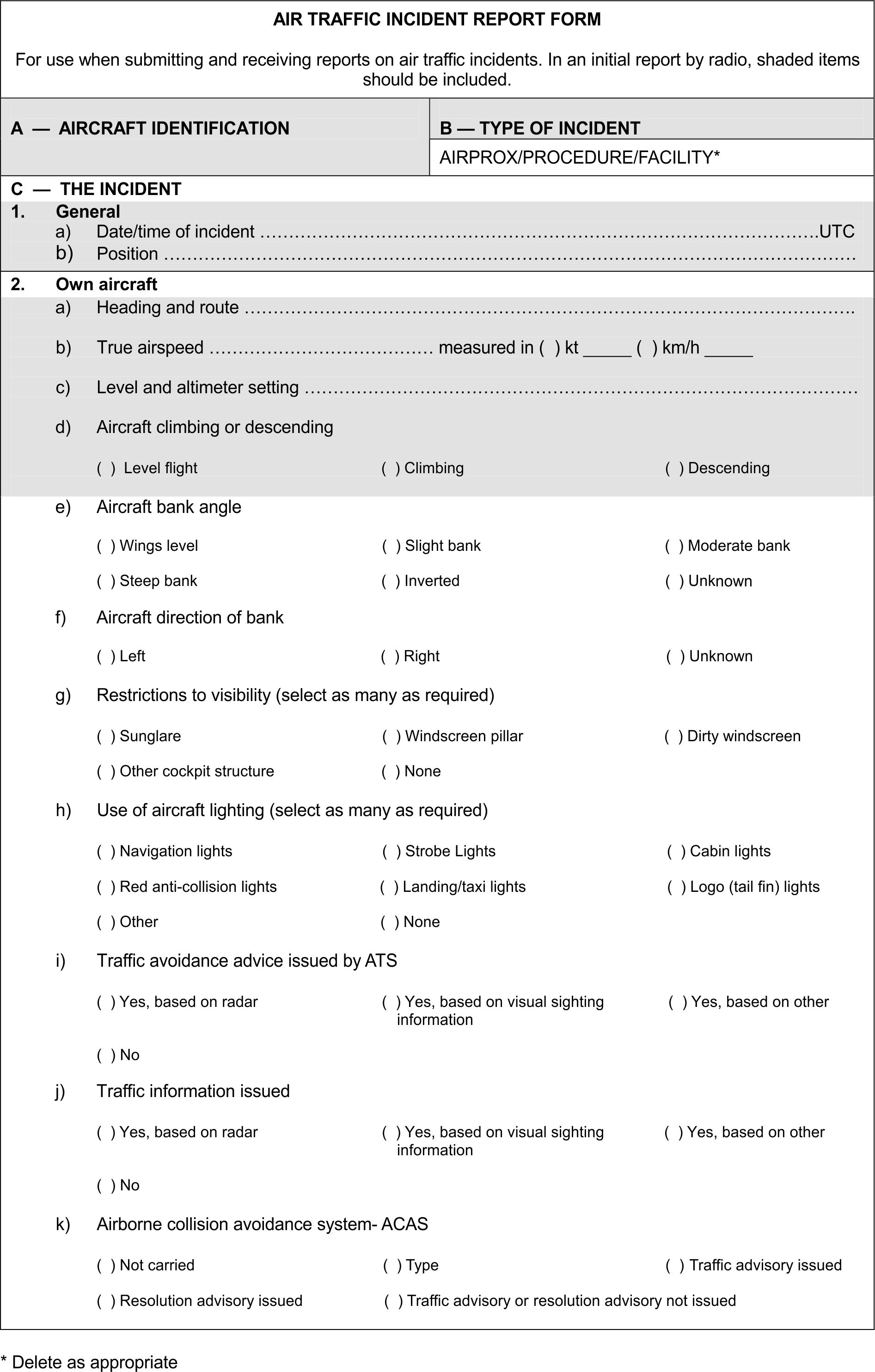
2 Use of the Air Traffic Incident Report Form
- by a pilot for filing a report on an air traffic incident after arrival or for confirming a report made initially by radio during flight.Note. — The form, if available on board, may also be of use in providing a pattern for making the initial report in flight.
- by an ATS unit for recording an air traffic incident report received by radio, telephone or teleprinter.Note. — The form may be used as the format for the text of a message to be transmitted over the AFS network.
3 Reporting procedures (including in-flight procedures)
- during flight, use the appropriate air/ground frequency for reporting an occurrence, particularly if it involves other aircraft, so as to permit the facts to be ascertained immediately;
- as promptly as possible after landing, but not later than 72HR after the occurrence, submit a completed Air Traffic Incident Report Form:
- for confirming a report of an occurrence made initially as in a) above, or for making the initial report on such an occurrence if it had not been possible to report it by radio;
- for reporting an occurrence which did not require immediate notification at the time of occurrence.
- aircraft identification;
- type of incident, e.g. aircraft proximity;
- the occurrence; 1. a) and b); 2. a), b), c), d), i); 4. a), b);
- miscellaneous: 1. e).
1. Ministry of Economy and Sustainable Development of Georgia
Civil Aviation and Maritime Transport Accident/Incident Investigation Bureau
Tel: +995 595 00 18 47
AFS: UGTBAIIB
Email: georgian-taiib@moesd.gov.ge
Email: dgiunashvili@moesd.gov.ge
and
2. Georgian Civil Aviation Agency
Tel: +995 32 236 40 51
Email: safety@gcaa.ge
Note. — Where there is no ATS Reporting Office, the report may be submitted to another ATS unit.
4 Purpose of reporting and handling of the form
| Item | |
| A | Aircraft identification of the aircraft filing the report. |
| B | An AIRPROX report should be filed immediately by radio. |
| C1 | Date/time UTC and position in bearing and distance from a navigational aid or in LAT/LONG. |
| C2 | Information regarding aircraft filing the report, tick as necessary. |
| C2 c) | E.g. FL350/ 1013 HPA or 2500 FT/QNH 1007 HPA or 1200 FT/QFE 998 HPA. |
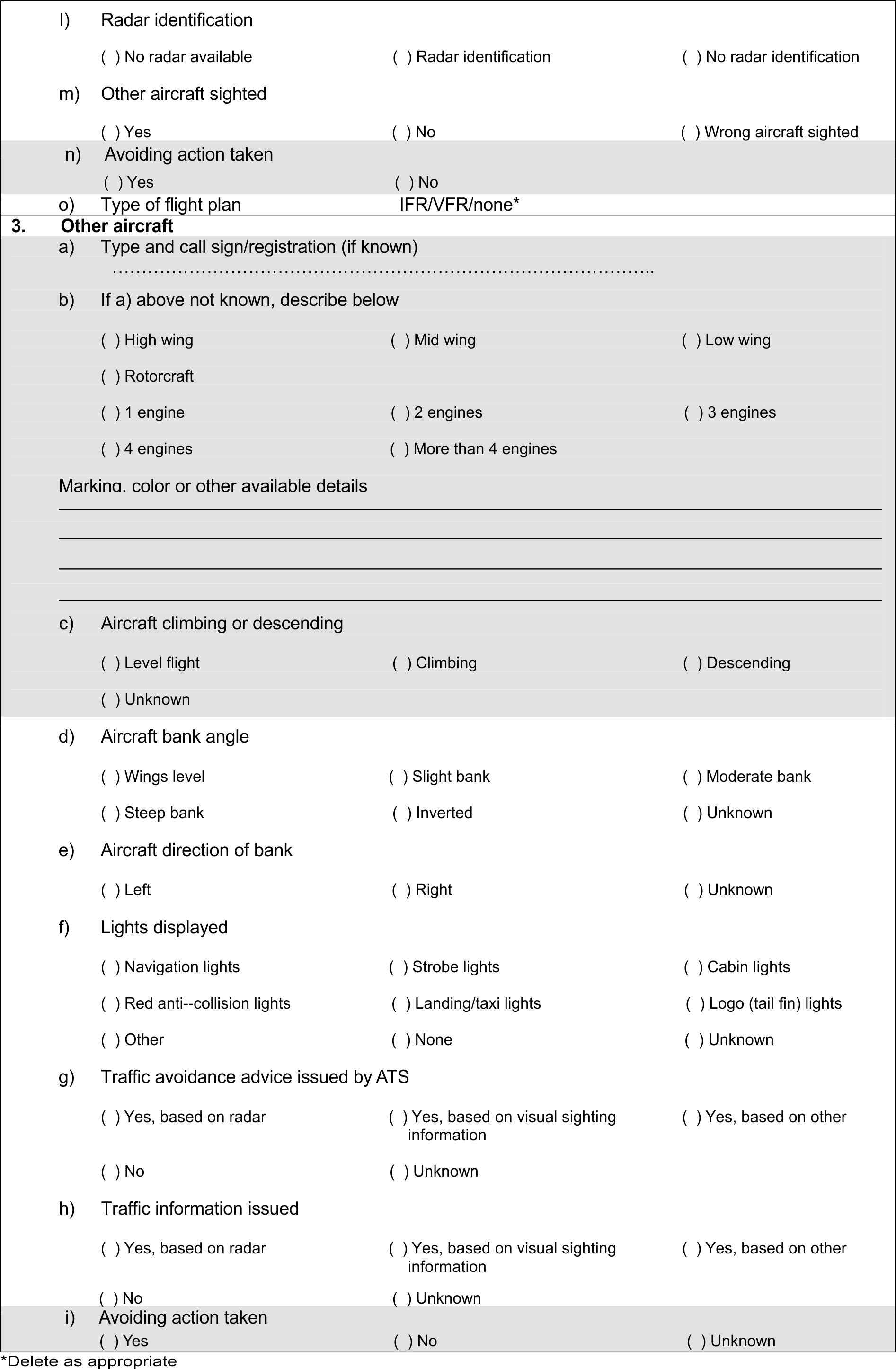
| C3 | Information regarding the other aircraft involved. |
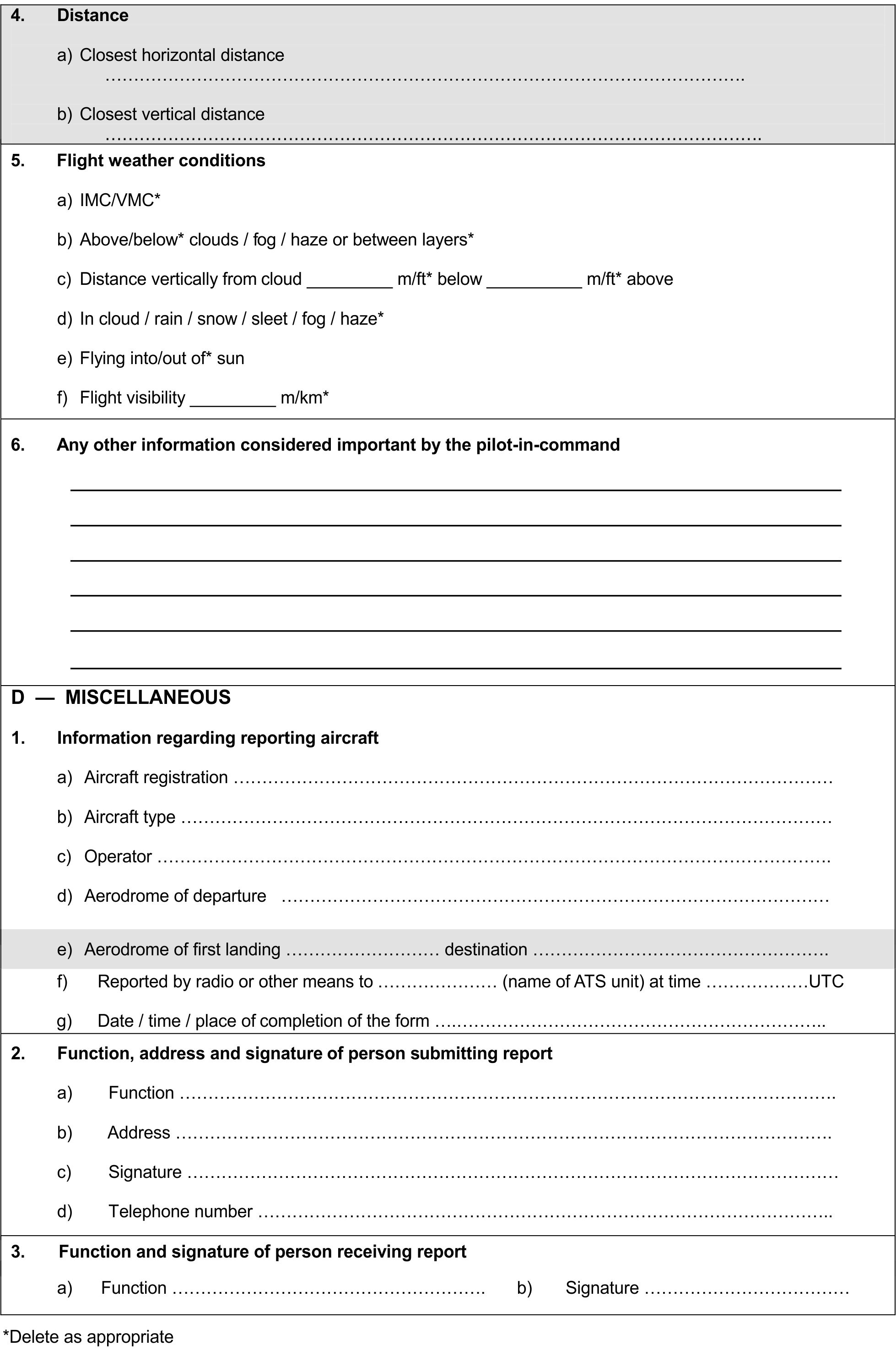
| C4 | Passing distance - state units used. |
| C6 | Attach additional papers as required. The diagrams may be used to show aircraft's positions. |
| D1 f) | State name of ATS unit and date/time in UTC. |
| D1 g) | Date and time in UTC. |
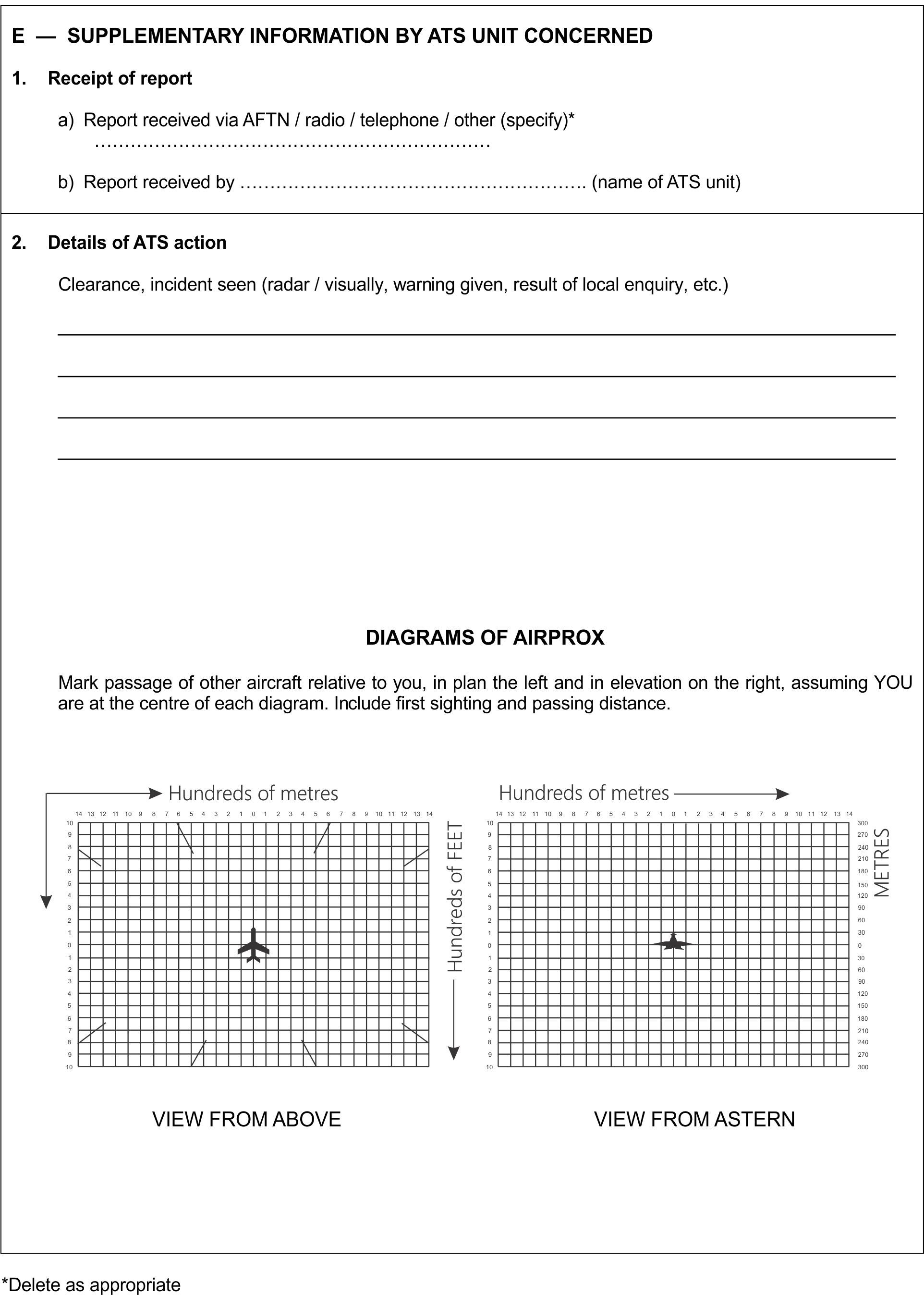
| E2 | Include details of ATS unit such as service provided, radiotelephony frequency, SSR codes assigned and altimeter setting. Use diagram to show the aircraft's position and attach additional papers as required. |
 |
 |
 |
 |